written by Stu Garrett
A sense of challenge arose in Stu Garrett, a doctor, a historian and Bend resident, when he heard one too many times that the highway from Bend to Burns was “the most boring road in Oregon.” Within three years, Garrett produced a manuscript of historical, geological and ecological scholarship milepost-by-milepost from Bend to Burns. The events of Highway 20 are perhaps Oregon’s most interesting combination of geology, and Native American and pioneer culture in one stretch.
The Great Basin
The large, usually dry lake basins of Harney and Lake Counties are the northern-most extension of the Great Basin. The Great Basin is part of the Basin and Range province, which extends into Mexico. Because there is no river outlet to an ocean, all precipitation falling in the Great Basin must evaporate. In cooler wetter times, some of these basins held lakes that were more than 300 feet deep. The Great Basin is also an area of thin crust, high heat flow from the center of the earth and recent volcanic eruptions. The Basin and Range is a part of the Earth’s crust that has been expanding for the last 15 million years. It may have widened more than 200 miles. It has probably expanded more than twice its original width and is still expanding at about 1 centimeter per year
The Bannock-Paiute Indian War of 1878 in Oregon
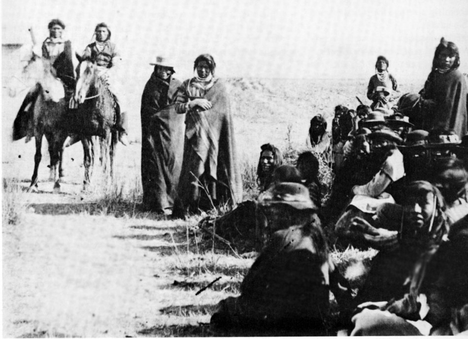
The Bannock War, also called Egan’s War, started in 1878 after settlers on Camas Prairie in Idaho allowed their hogs to root up and destroy camas fields that were the basis for the Bannock Tribe’s sustenance. It was the last in a growing body of transgressions against the Bannock Tribes. After leading a revolt against the whites on Camas Prairie, Buffalo Horn led the Bannocks from the Fort Hall Reservation to eastern Oregon to join with the Paiute tribes. A battle between soldiers and Indians, now led by Paiute Chief Egan, occurred at Silver Creek, not far from the present town of Riley, 24 miles west of Burns. Colonel Reuben F. Bernard found the Indians encamped at Silver Creek on a rocky flat near the abandoned site of the U.S. Army Camp Curry. The Paiutes and Bannocks numbered nearly 2,000. Of this group, 700 were warriors. The soldiers were outnumbered, but Bernard led a surprise attack on the morning of June 23, 1878. One soldier and an estimated ten to fifty Indians were killed, before the Indians fled to the north through Grant County.
Rabbit Drives
The Paiute Indians were a resourceful people. They utilized everything in their environment that could possibly benefit them. One strategy for getting meat and fur pelts involved driving rabbits into a rope fence and clubbing them. The early homesteaders copied Paiute methods to reduce the hordes of rabbits that would eat gardens and crops.
The Sheep Wars
Between the years of 1896 and 1906, Central Oregon was the site of armed conflict between sheepherders and cattlemen that eventually led to the killing of more than 10,000 sheep and a number of people. These range wars included the burning of numerous ranches, sheep sheds, haystacks, and the killing of cattle. It began with the formation of several associations, whose leaders and members remain unknown to this day. This led to the largest slaughter of sheep that took place in the American West.
Milepost History
MILE 9: Your Taxpayer Dollars, Torpedoed
The Central Oregon Testing Facility (COTEF) is located north of the highway just out of view. In the early 1980s, during the Cold War, the U.S. government built this installation. This site was said to be connected to a Redmond facility and to the Backscatter Radar in Christmas Valley, 50 miles to the south. This $3 billion radar installation was meant to intercept Russian bombers flying over Siberia and Alaska to attack the U.S.
FACT:
U.S. Route 20 is an east-west United States highway. As the “0” in its route number implies, U.S. 20 is a coast-to-coast route.
MILE 13: Badlands Volcano
This volcanic feature is probably a “rootless volcano” related to the Newberry Volcano complex. “Rootless” because it has no direct pipe to the crustal source of magma, instead likely connected to the Newberry Volcano by a shallow lava tube or tubes. It has some spectacular ancient junipers struggling for centuries on the stark lava. If you haven’t hiked here on a clear winter day, turn to page 50 for more.
MILE 22: Newberry Volcano
This volcano to the south is a shield-shaped volcano with multiple cinder cones on its flanks. The earliest flows date to 600,000 years ago. In 1991, this area became Oregon’s fourth National Monument, protecting its fascinating geology, old growth ponderosa pines and plant communities.
MILE 42: Henry L. Davis, a Sweet Pulitzer
Davis was the only Oregon author to win a Pulitzer Prize for literature. Awarded in 1936 for his novel, Honey in the Horn, it is a story of rough characters in early Crook County.


